Safety Rest Areas: Culberson County (near Pine Springs)
(Reconstructed facility opened in 2001)
|
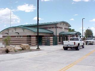 View of the new Culberson County Safety Rest Area |


Location
|
Features
Miscellaneous
- Reconstructed facility completed in 2001 with expanded restroom facility and more parking
- Walls of the new facility resemble exposed rock strata along the surrounding mountains. The curved roofs reduce wind pressure and rhyme with the mountain ridges in the distance
- Equipped with a wind turbin to supply renewable energy to the facility
- Culberson County is best known as the site of Guadalupe Mountains National Park, which includes Guadalupe Peak, the highest point in Texas at 8,749 feet
- The Guadalupes are home to several endangered or locally rare plant species, including bigtooth maple, ponderosa pine, chinquapin oak, Rocky Mountain juniper, Texas madrone, and Mexican buckeye, and of the only elk in Texas